General Thomas Jackson awoke early on the morning of Wednesday, May 7, 1862, in his room at the Virginia Hotel in Staunton, Virginia. Sporting a new haircut, he dressed himself in a “full new suit of Confederate grey.” He ate a light breakfast and strolled outside where he found his horse saddled, awaiting his employment. Christened “Little Sorrel” the mount was a Morgan horse captured by his men at Harper’s Ferry in 1861. Initially it was meant as a gift for his wife. “After riding the horse Jackson found the animal’s gait so pleasing, he determined to keep it for himself.” Jackson later commented: “A seat on him was like being rocked in a cradle.”

Little Sorrel at VMI after the Civil War
Mounting his warhorse Stonewall gave the beast a gentle kick and was off. Riding alone, along the Middlebrook Road toward Lexington, Jackson soon found a “byroad” and, bearing off to the north, headed back toward West View and the Staunton-Parkersburg Turnpike. Jackson’s staff, however, traveling some distance behind him “were so totally ignorant in reference to the movements of the army, that upon the report of some one that the General had taken the Lexington road, they also started that way, but learning he had turned off they followed after him, but only overtook him, after a ride of 25 miles from Staunton to Roger’s Toll Gate in Ramsey’s Draft.”
The Staunton-Parkersburg Turnpike would serve as the avenue over which General Robert Milroy’s Federal Army would be confronted during this segment of Jackson’s 1862 Valley Campaign. The road featured first-rate construction standards and employed an advanced Macadam style of paving. This revolutionary mode of construction rendered roads more durable and greatly enhanced travel under nearly all weather conditions. Although the surveys for this toll road had begun in the early 1830s, actual construction had not begun until 1838. This 220-mile-long road was built by local laborers with each team taking responsibility for a 20-mile segment of the highway. The work had started simultaneously in Parkersburg and Staunton with the last section being completed between Buckhannon and Weston in 1845.

Route of Jackson’s Army from West View to Fort Edward Johnson along the Staunton-Parkersburg Turnpike.
Jackson’s staff, which had been so misled by his secretive intentions, was by all other standards quite exceptional. There were “three present or future doctors of divinity, eleven holders of master’s degrees or higher, four attorneys, and nine educators; and hardly any of them older than 30.” One of Stonewall’s most treasured staff members, however, was his topographical engineer Jedediah Hotchkiss.
Born in 1828, Jedediah Hotchkiss was a native of Windsor, New York. Following graduation, Hotchkiss spent a year teaching school in Lykens Valley, Pennsylvania. When the school year ended in the Spring of 1848, “he and a friend decided to take an extended walking tour of the Shenandoah Valley of Virginia.” During this journey, he met Henry Forrer of the Shenandoah Iron Works. Henry invited him to Mossy Creek to meet his brother Daniel “who was looking for a young scholar to tutor his children.” That fall he schooled the Forrer family at Mossy Creek. Hotchkiss’ success over the next several years resulted in the establishment of Mossy Creek Academy in 1853. He would serve as a teacher and its principal for the next five years.

Jedediah Hotchkiss
In 1858 Hotchkiss resigned his position at Mossy Creek to establish his own school at Churchville in Augusta County. This institute, christened Loch Willow School for Boys, blossomed over the next three years until the outbreak of the Civil War. It was in the Spring of 1861 when students began to leave “Loch Willow in droves.” While “older students volunteered for military duty, the younger ones were anxious to be with their families at this uncertain time.” Hotchkiss was left with little choice; “The school really closed itself.”
In late June of 1861, in spite of the lack of formal training, Hotchkiss offered his services to the Confederate Army as a mapmaker. General Richard S. Garnett quickly tasked him as his topographical engineer and on July 2, 1861, he was assigned to duty under Lieutenant Colonel Jonathan Heck on Rich Mountain. He was immediately ordered to initiate a survey of Camp Garnett and vicinity.
On July 11, 1861, the Rebel position on Rich Mountain was attacked by General George McClellan’s troops. A sharp two-hour fight ensued in which Confederate forces were split in two. Seeking to escape capture, Colonel Heck left Camp Garnett at 1:00 a.m. on June 12 with most of the remaining Confederate soldiers. “Hotchkiss, who was known as Professor Hotchkiss, led the way, followed by Captain Robert Doak Lilley’s company of the 25th Virginia.” During a heavy downpour, “Hotchkiss, serving as adjutant on the retreat, led the troops over mountains and through swamps to safety.”
Hotchkiss’ early service, however, was cut short due to a bout with typhoid fever. The illness forced him to return home to Loch Willow to recuperate. By March of 1862, though, Hotchkiss considered himself fit for duty once again. When Governor Letcher called out the militia that month, Jed decided he would return to the military hopeful he could get an appointment as an Army Engineer.
Hotchkiss would get his wish on March 25, when Major General Thomas Stonewall Jackson engaged Hotchkiss to prepare “a map of the Valley, from Harpers Ferry to Lexington, showing all the points of offence and defense in those places.” The resulting topographic map would prove instrumental to Jackson’s success in the 1862 Valley Campaign.
When Jackson’s nine-thousand-man army began its advance along the Staunton-Parkersburg Turnpike on their way to McDowell, they soon came into contact with Union Troops near Ramsey’s Draft. At the junction of the Parkersburg Turnpike and the Harrisonburg-Warm Springs Road, elements of the 52nd Virginia collided with Company L of the 1st West Virginia Cavalry under Captain Jacob Shuman. A sharp but ephemeral skirmish ensued in which the Confederates “killed and wounded several of the enemy, captured stores, etc.”
Subsequent to the skirmish at the crossroads, the vanguard of the army pushed on to Rogers’ Toll Gate. It was believed “the main body of the enemy’s advance, had retreated up Shenandoah Mountain but is supposed to still be holding our ‘Fort Johnson’ at the pass on the top.” Here Generals Jackson and Johnson were joined by mapmaker Jedediah Hotchkiss and a plan was soon formulated to seek out the enemy.

Detail Map showing Skirmish location, Rogers’ Tollgate, and Fort Johnson.
With a probable combat situation looming on the heights above them, Jackson selected his unarmed mapmaker, Jed Hotchkiss, to lead a team of skirmishers to the top of Shenandoah Mountain to determine if Union forces were holding Fort Johnson. Hotchkiss recalled: “The General ordered me to go up the spur of the mountain on our right, preceded by a line of skirmishers, and ascertain whether the enemy had left the top of the mountain, Col. Williamson doing the same thing on the left. We had a hard scramble up the steep slope of the spur but finally reached the top only to find the enemy all gone but seeing their rear guard on the top of Shaw’s Ridge, the next one beyond us. We returned to Wm Roger’s at the Toll Gate, where Hd. Qtrs. were established for the night.”
Hotchkiss’s combat assignment would resume the following day. Early on the morning of May 8, the army pushed on across Shaw’s Ridge meeting no opposition from General Milroy’s troops. General Jackson sent Jed Hotchkiss along ahead to lead the army’s advance. Hotchkiss remembered he was “in advance, with skirmishers, up the winding turnpike road along an eastward spur of Bull Pasture Mountain, and when, at each turn of the road, I found the way clear I waved my handerchief, then he came on with the main column. So doing we soon reached the gap at the summit two miles from Wilson’s and three miles back from McDowell, as our progress was unopposed.”

Sketch of Fort Edward Johnson on Shenandoah Mountain.
Upon reaching the summit of Bull Pasture Mountain Jackson and Hotchkiss rode out “to the right of the gap to the end of a rocky spur overlooking the Bull Pasture Valley and showed him the enemy in position near McDowell. At the same time, he looking on, I made him a map of McDowell and vicinity, showing the enemy’s position, as in full view before us.”
Returning to their origin atop Bull Pasture Mountain, Hotchkiss remembered that he and Jackson “with great difficulty rode up a steep, rough way, along a gorge, to the cleared fields on the top of the mountain to our left, called Sitlington’s Hill, where Gen. Jackson had already taken his command and placed it in concealment and was studying the enemy’s position.” Here Hotchkiss, Johnson, and Jackson rode to the crest of the mountain to survey the town. “The Federals soon discovered the party, and believing they were trying to place artillery, fired on them with their skirmishers from their concealed position on the slope below.” The party was forced to retire to the woods in their rear.

Hotchkiss Map of the Battle of McDowell.
Hotchkiss withdrew from the soon to be battlefield and rode back to the home belonging to John Wilson on the Cow Pasture River. As it appeared there would be no hostilities that day, Jed helped himself to dinner. While he was dining, though, he soon heard the echo of cannon fire in the distance. He quickly mounted his horse and rode to the sound of the guns where he found Jackson at the top of Bull Pasture Mountain “all alone in the road in the gap. He at once sent me down the road towards McDowell to see what was going on; he had already sent back to Shaw’s Fork for the Stonewall Brigade and seemed very anxious for it to arrive.”
The Battle of McDowell, having begun about 4:30 in the afternoon, was over by early evening. Though a Confederate victory, in that short time-period 532 Confederate soldiers had fallen as had 259 Union troops. Even General Edward Johnson would be removed from the field with an ankle wound. That evening, before Jackson retired, he instructed Jed to return to the mountain about 3 a.m. the next morning to “see about opening a road up to Sitlington’s Hill, where we had been engaged in the fighting, for taking up artillery and must ascertain whether the enemy had left McDowell.”
As instructed, at 3 a.m. precisely, Hotchkiss rode to the top of Sitlington’s Hill to establish a pathway to push artillery to the top of the ridge. In the process he “learned from the pickets that the enemy had retired from McDowell, so sent word to Gen. Jackson and then rode to examine and sketch the battle-field on Sitlington’s Hill.
In the aftermath of the fighting, it was determined that the army was “’too tired’ to begin a pursuit of the enemy on May 9. Instead, Jackson took up headquarters in the Phoenix Hull house. Jackson’s men descended upon the town and spent the day cooking rations for the continuation of the campaign. The pioneers and a contingent of cadets from VMI would dedicate their day to burying the dead “in the bend of the road near the mouth of our path ravine by which we went to the Battlefield.”

Hull House, Jackson’s and Milroy’s Headquarters at McDowell.
Jackson’s men were up early and in pursuit of the Union Army on the morning of the 10th. After the throng had moved some ten miles toward Franklin, however, General Jackson called Hotchkiss to his side once more. He had one more mission for his mapmaker to undertake. Hotchkiss was ordered “to ride back, with all possible dispatch, and blockade the roads leading through North River and Dry River Gaps, from the Franklin Road into the Valley, riding by way of Churchville and taking as many of the cavalry encamped there, under Maj. Jackson.” Hotchkiss informed Jackson that the major was a drunkard, and he instead asked permission to use Captain Frank Sterrett’s Company to assist him with his mission.
Hotchkiss arrived back at his home at Lock Willow that very evening. At 3 a.m. the following morning he departed Churchville with his cavalry escort “by way of Stribling Springs across to James Todd’s and blockaded North River Gap road by falling trees into it and obstructing it in other ways.” They then rode to “Dry River Gap and blockaded the Harrisonburg and Franklin Road in the gap beyond Rawley Springs.” With the sudden appearance of Union Cavalry near their location, however, they “procured axes and crowbars from citizens near the entrances to the gaps from the valley and by sending details far up into the gaps…and cutting down trees and large rocks into the road as we withdrew we made a very effectual blockade.”
Following the war when speaking to a General Thomas, “an assistant General of the Federal Army during the war,” he reported that during late May 1862 General Freemont had been ordered by President Lincoln to march from Franklin to Harrisonburg to cut off Jackson’s retreat through the region. “Freemont had replied that the road was blockaded and he could not do it.” Hotchkiss had in fact done such a good job obstructing the pathway that it would not be reopened until well after the conclusion of the Civil War.
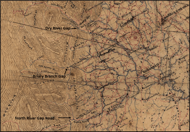
Dry River, Briary, and North River Gaps Blocked by Jedediah Hotchkiss.
On May 18, Jackson would receive one more invaluable assist from Hotchkiss as he was scrambling to find a way to cross his army over the North River at Bridgewater. Stonewall had himself ordered the burning of the bridge earlier in the campaign. When asked by the army commander how he could traverse the river Hotchkiss “suggested a wagon bridge, telling him how numerous the four and six horse wagons were in the area. He adopted my suggestion and ordered Cp C.R. Mason with his negro pioneers and the quartermaster to carry it out.” The scheme was a resounding success.
As we have witnessed Jackson would often ask Hotchkiss to lead his columns, even in combat situations. Jackson did this because he believed Hotchkiss was dependable and would complete his assignments successfully. This trend would continue throughout the remainder of the Valley Campaign including an assignment to burn bridges on the South Fork of the Shenandoah River, and even leading an assault on the Coaling at Port Republic.
Hotchkiss’s knowledge of the Valley and its inhabitants proved helpful in numerous situations. “The Hotchkiss-Jackson collaboration bred success, especially for the general’s lightning strikes which depended heavily on making the most of the terrain.” Hotchkiss’s topographic maps were instrumental to Jackson’s overall success in the 1862 Valley Campaign and beyond.
At the Battle of Chancellorsville, it was Hotchkiss who discovered the route for Jackson’s dramatic flank attack. After Jackson’s mortal wounding, to which Hotchkiss was a witness, Hotchkiss continued as a topographical engineer with the Confederate Army, frequently working directly for General Robert E. Lee. Maps produced by Hotchkiss would also directly benefit General Jubal Early during the 1864 Valley Campaign.
After the war, Hotchkiss opened an engineering firm and taught school in Staunton. In October 1865, “a Federal detective confronted Hotchkiss with a military order to confiscate his map collection.” Hotchkiss flatly declined to obey the mandate and despite Federal pressure, was able to retain ownership of all his charts. In the end C. Vernon Eddy, a librarian at the Handley Regional Library in Winchester, “made arrangements for the listing and safe-keeping of the maps in specially-made aluminum tubes, before they were finally given to the Library of Congress in 1948.”
“The Jedediah Hotchkiss Papers are currently available in the Stewart Bell Jr. Archives Room through the Winchester-Frederick County Historical Society at Handley Regional Library.” Hotchkiss would go on to publish a number of scientific articles about the flora and fauna of Virginia and pursued a successful postwar career as both a geologist and an engineer. Hotchkiss died on January 17, 1899 at the age of 71. He is buried at Thornrose Cemetery in Staunton.
Lets hope for prosperous and healthy new year for us all. God Bless.
Sources:
Hotchkiss, Jedediah. Make Me a Map of the Valley: The Civil War Journal of Stonewall Jackson’s Topographer. Southern Methodist University Press. Dallas, Texas. 1973.
Roper, Peter W. Jedediah Hotchkiss: Rebel Mapmaker and Virginia Businessman. White Mane Publishing Company. Shippensburg, Pa. 1992.
Library of Congress Hotchkiss Map Collection. https://www.loc.gov/collections/hotchkiss-maps/articles-and-essays/the-hotchkiss-collection-of-confederate-maps/
https://www.battlefields.org/learn/biographies/jedediah-hotchkiss

A delightfully detailed yet concise treatment of one of Jackson’s most valuable assets. Having followed the path of Jackson’s First Valley Campaign under the expert guidance of Peter Dalton, I got a good education in just how valuable Hotchkiss’ maps were. Hotchkiss himself showed remarkable courage and tenacity when he undertook “scouting” missions. Hotchkiss seems to me to have been one of those great historical characters who comes out of nowhere and leaves a legacy that grows to legendary status long after he has left the planet. Thank you for posting this fine article.
LikeLike
Hi Pete –
Extremely interesting, as usual! Thanks for sending! Someday I want to hike the old macadam road (in the spring) that leads to the McDowell battlefield.
I remember you saying the actual battlefield was grown up in trees now; is it possible to get into it on foot?
Best wishes to you and yours,
Otis Fox
LikeLike